![](/images/other/stat-length.png)
![Tour Wandern Six-Fours les Plages - trace - Photo](https://media.geolcdn.com/t/1900/400/ext.pjpeg?maxdim=2&url=https%3A%2F%2Fstatic1.geolcdn.com%2Fsiteimages%2Fupload%2Ffiles%2F1553511878bg_sport_marche.png)
trace
CSMSRANDOS
Benutzer
![Länge](/images/other/stat-length.png)
Länge
6,3 km
![Maximale Höhe](https://static1.geolcdn.com/siteimages/upload/files/1508320355ic_sort_altitude_max_24dp.png)
Maximale Höhe
234 m
![Positive Höhendifferenz](https://static1.geolcdn.com/siteimages/upload/files/1508320355ic_sort_den_pos_24dp.png)
Positive Höhendifferenz
243 m
![Km-Effort](/images/other/stat-length.png)
Km-Effort
9,6 km
![Min. Höhe](https://static1.geolcdn.com/siteimages/upload/files/1508320355ic_sort_altitude_min_24dp.png)
Min. Höhe
69 m
![Negative Höhendifferenz](https://static1.geolcdn.com/siteimages/upload/files/1508320355ic_sort_den_neg_24dp.png)
Negative Höhendifferenz
250 m
![Boucle](https://static1.geolcdn.com/siteimages/upload/files/16400158638029165_repeat_loop_refresh_sync_direction_icon.png)
Boucle
Ja
Erstellungsdatum :
2024-01-29 21:03:05.393
Letzte Änderung :
2024-01-29 21:04:50.447
![Wandern](https://static1.geolcdn.com/sitytour/trail-icons/101.png)
2h10
Schwierigkeit : Medium
![Scannen Sie diesen QR-Code, um die Tour in der SityTrail-Anwendung zu öffnen](https://capi.geolives.com/qq0zvz2zws4bq2lad0pu/sitytour/trails/3932287/qr.png?size=200)
Kostenlosegpshiking-Anwendung
Über SityTrail
Tour Wandern von 6,3 km verfügbar auf Provence-Alpes-Côte d'Azur, Var, Six-Fours les Plages. Diese Tour wird von CSMSRANDOS vorgeschlagen.
Beschreibung
Aire des Masques
Le Montanier
Les culs de Caravailles
Piste de Francillon
Piste des chênes blancs
Piste des pins parasol
Ort
Land:
France
Region :
Provence-Alpes-Côte d'Azur
Abteilung/Provinz :
Var
Kommune :
Six-Fours les Plages
Standort:
Unknown
Gehen Sie:(Dec)
Gehen Sie:(UTM)
731760 ; 4771774 (31T) N.
Kommentare
Touren in der Umgebung
![Tour Wandern Six-Fours les Plages - ND de Pepiole via colline du fort de Six-Fours, retour par Les Lônes - Photo](https://media.geolcdn.com/t/375/260/1379151f-75a9-4587-8d69-64d0542e06ca.jpg&format=jpg&maxdim=2)
![Wandern Wandern](https://static1.geolcdn.com/sitytour/trail-icons/101.png)
ND de Pepiole via colline du fort de Six-Fours, retour par Les Lônes
Wandern
Einfach
(1)
Six-Fours les Plages,
Provence-Alpes-Côte d'Azur,
Var,
France
![](/images/other/stat-length.png)
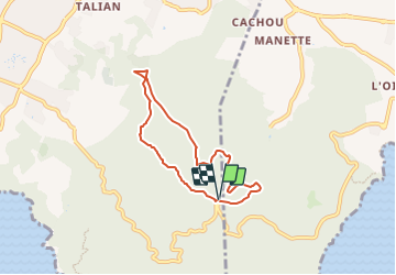
8,2 km | 10,7 km-effort
3h 0min
![](https://static1.geolcdn.com/siteimages/upload/files/16400158638029165_repeat_loop_refresh_sync_direction_icon.png)
Ja
![Tour Wandern Six-Fours les Plages - Le sentier du littoral - Photo](https://media.geolcdn.com/t/375/260/b906d75c-22ca-4676-a4ea-efd131997cad.jpeg&format=jpg&maxdim=2)
![Wandern Wandern](https://static1.geolcdn.com/sitytour/trail-icons/101.png)
Le sentier du littoral
Wandern
Schwierig
(1)
Six-Fours les Plages,
Provence-Alpes-Côte d'Azur,
Var,
France
![](/images/other/stat-length.png)
11 km | 15,8 km-effort
3h 23min
![](https://static1.geolcdn.com/siteimages/upload/files/16400158638029165_repeat_loop_refresh_sync_direction_icon.png)
Ja
![Tour Wandern Six-Fours les Plages - ND de Pepiole via colline du fort de Six-Fours - Photo](https://media.geolcdn.com/t/375/260/1379151f-75a9-4587-8d69-64d0542e06ca.jpg&format=jpg&maxdim=2)
![Wandern Wandern](https://static1.geolcdn.com/sitytour/trail-icons/101.png)
ND de Pepiole via colline du fort de Six-Fours
Wandern
Einfach
(1)
Six-Fours les Plages,
Provence-Alpes-Côte d'Azur,
Var,
France
![](/images/other/stat-length.png)
8,7 km | 12,3 km-effort
3h 0min
![](https://static1.geolcdn.com/siteimages/upload/files/16400158638029165_repeat_loop_refresh_sync_direction_icon.png)
Ja
![Tour Wandern La Seyne-sur-Mer - fabregas parking du bœuf, plage des nudistes, sémaphore, notre dame de mai. - Photo](https://media.geolcdn.com/t/375/260/d2496b6d-773d-4991-9a61-fe4c8adf1522.jpg&format=jpg&maxdim=2)
![Wandern Wandern](https://static1.geolcdn.com/sitytour/trail-icons/101.png)
fabregas parking du bœuf, plage des nudistes, sémaphore, notre dame de mai.
Wandern
Medium
(3)
La Seyne-sur-Mer,
Provence-Alpes-Côte d'Azur,
Var,
France
![](/images/other/stat-length.png)
10,2 km | 16,3 km-effort
2h 52min
![](https://static1.geolcdn.com/siteimages/upload/files/16400158638029165_repeat_loop_refresh_sync_direction_icon.png)
Ja
![Tour Mountainbike La Seyne-sur-Mer - Cap Sicié - Fabregas - Photo](https://media.geolcdn.com/t/375/260/ext.jpg?maxdim=2&url=https%3A%2F%2Fservices.sitytrail.com%2FGeolivesWS%2FDownloadMedia.ashx%3FTrailID%3D105841%26Media%3D9806_1.jpg)
![Mountainbike Mountainbike](https://static1.geolcdn.com/sitytour/trail-icons/202.png)
Cap Sicié - Fabregas
Mountainbike
Schwierig
(3)
La Seyne-sur-Mer,
Provence-Alpes-Côte d'Azur,
Var,
France
![](/images/other/stat-length.png)
18,3 km | 26 km-effort
2h 40min
![](https://static1.geolcdn.com/siteimages/upload/files/16400158638029165_repeat_loop_refresh_sync_direction_icon.png)
Ja
![Tour Wandern Six-Fours les Plages - Randonnée - Roumagnan - Dolmen de La Lèque - Sentier du Littoral - Photo](https://media.geolcdn.com/t/375/260/e37183bf-4c1c-448c-8453-7e7135227837.jpg&format=jpg&maxdim=2)
![Wandern Wandern](https://static1.geolcdn.com/sitytour/trail-icons/101.png)
Randonnée - Roumagnan - Dolmen de La Lèque - Sentier du Littoral
Wandern
Medium
Six-Fours les Plages,
Provence-Alpes-Côte d'Azur,
Var,
France
![](/images/other/stat-length.png)
7,3 km | 12 km-effort
4h 0min
![](https://static1.geolcdn.com/siteimages/upload/files/16400158638029165_repeat_loop_refresh_sync_direction_icon.png)
Ja
![Tour Wandern Six-Fours les Plages - Cap Sicié - Notre Dame du Mai - Six fours - Photo](https://media.geolcdn.com/t/375/260/5d40a7c9-6bdb-4d87-9016-02770321b032.jpg&format=jpg&maxdim=2)
![Wandern Wandern](https://static1.geolcdn.com/sitytour/trail-icons/101.png)
Cap Sicié - Notre Dame du Mai - Six fours
Wandern
Medium
Six-Fours les Plages,
Provence-Alpes-Côte d'Azur,
Var,
France
![](/images/other/stat-length.png)
8,1 km | 13,4 km-effort
3h 53min
![](https://static1.geolcdn.com/siteimages/upload/files/16400158638029165_repeat_loop_refresh_sync_direction_icon.png)
Ja
![Tour Wandern La Seyne-sur-Mer - janas - Photo](https://media.geolcdn.com/t/375/260/ext.jpg?maxdim=2&url=https%3A%2F%2Fstatic1.geolcdn.com%2Fsiteimages%2Fupload%2Ffiles%2F1553511878bg_sport_marche.png)
![Wandern Wandern](https://static1.geolcdn.com/sitytour/trail-icons/101.png)
janas
Wandern
Einfach
(2)
La Seyne-sur-Mer,
Provence-Alpes-Côte d'Azur,
Var,
France
![](/images/other/stat-length.png)
11,8 km | 17,6 km-effort
1h 33min
![](https://static1.geolcdn.com/siteimages/upload/files/16400158638029165_repeat_loop_refresh_sync_direction_icon.png)
Ja
![Tour Wandern Saint-Mandrier-sur-Mer - Presqu'île de Saint-Mandrier - Photo](https://media.geolcdn.com/t/375/260/ext.jpg?maxdim=2&url=https%3A%2F%2Fstatic1.geolcdn.com%2Fsiteimages%2Fupload%2Ffiles%2F1553511878bg_sport_marche.png)
![Wandern Wandern](https://static1.geolcdn.com/sitytour/trail-icons/101.png)
Presqu'île de Saint-Mandrier
Wandern
Einfach
(1)
Saint-Mandrier-sur-Mer,
Provence-Alpes-Côte d'Azur,
Var,
France
![](/images/other/stat-length.png)
3,2 km | 4,4 km-effort
1h 45min
![](https://static1.geolcdn.com/siteimages/upload/files/16400158638029165_repeat_loop_refresh_sync_direction_icon.png)
Ja